Why This Matters
• Faster infrastructure decisions: Centimeter-accurate 3D canal models reduce survey timelines from weeks to days, meaning fewer project delays and faster permitting for waterfront developments.
• Flood protection intelligence: Precise bathymetric data powers flood-risk simulations, helping planners identify vulnerable areas and prioritize drainage improvements before heavy rains strike.
• Investment transparency: The data feeds Dubai's virtual city model, eventually giving property buyers and developers verifiable information about water proximity, flood risk, and future infrastructure plans.
The Channel Mapping Breakthrough
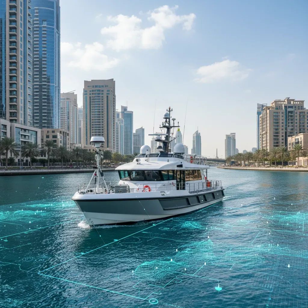
The Dubai Municipality has wrapped up a foundational surveying milestone: the region's first comprehensive mobile-mapping campaign of urban waterways, completed across the Dubai Water Canal corridor in Al Jaddaf during early May. The operation deployed the Leica TRK sensor platform—a vessel-mounted assembly combining LiDAR, thermal imaging, dual GPS receivers, and gyroscopic stabilization—to generate dense point-cloud datasets of the canal's geometry, bank structures, and overhead utilities in a single campaign.
What distinguishes this effort from conventional hydrographic work is scope. Traditional waterway surveys focus narrowly on seafloor depth profiles useful for navigation. The Leica TRK captures the full urban context: the precise dimensions of bridge soffit clearances, the positioning of underground utility casings crossing canal beds, pedestrian ramp access points, and emergency boat-launch locations. For a city planning authority, this translates to eliminating the need for fragmented surveys and reducing the risk of costly project collisions with unmapped infrastructure.
The pilot data is already flowing into the municipality's internal planning systems, where engineers are stress-testing it against existing Building Information Models and utility registries. Early results indicate the accuracy threshold—positioning correctness within centimeters—meets international standards for infrastructure design work.
How Speed Reshapes Urban Planning
The traditional approach to waterway surveying in urban settings involves multiple phases. Survey crews stage ground-control points along canal banks, deploy boat-mounted echo-sounder equipment to map the streambed in passes spanning days or weeks, then manually integrate terrestrial measurements from different instruments into a single coherent dataset. The process typically requires weeks of coordination and field time, especially in complex urban settings where traffic, permit restrictions, and utility conflicts force schedule adjustments.
The Leica TRK system collapses this timeline. Operating from a single specialized survey vessel, the platform captures 360-degree imagery, ranging data, and position telemetry simultaneously as it traverses the canal at normal navigation speeds. Processing occurs overnight: software automatically detects building edges, water surfaces, and utility markers, georeferencing the entire dataset to a common coordinate frame. The municipality's GIS Centre receives finished 3D models within 48 hours of fieldwork completion.
This velocity is consequential for a city like Dubai, where major waterfront projects—the planned creek dredging, marina expansions in Business Bay, pedestrian bridge networks—queue for design approval. Consultants can now pull verified spatial data from the municipality's portal instead of commissioning independent surveys, saving weeks of preliminary work and lowering project costs proportionally.
What Accurate Canal Data Unlocks
For Dubai's resident population—nearly 85% expatriates—the practical benefit sits at the intersection of property investment and urban resilience. Waterfront real estate commands premium pricing, but so does uncertainty about flood risk, infrastructure proximity, or future construction impacts. The detailed 3D canal models emerging from this survey reduce that information asymmetry.
Developers evaluating waterside sites can now download verified depth profiles, bank-stability assessments, and subsurface utility coordinates from the municipality's geospatial database. Architects design marinas and pedestrian access facilities with confidence, knowing the underlying canal geometry matches their models. Insurance underwriters, reviewing flood-risk assessments, benefit from more granular hazard mapping that distinguishes between high-risk narrow sections and broader reaches with superior drainage capacity.
For property owners in Al Jaddaf and surrounding neighborhoods, the data feeds into the Dubai Municipality's predictive maintenance protocols. Cracked seawalls, sediment accumulation, and drainage blockages—typically discovered during emergencies—now appear as data points in the city's asset-monitoring dashboards. Maintenance crews can address issues before they cascade into service disruptions or safety hazards.
Beyond property considerations, the waterway intelligence supports Dubai's ambition to operate the region's most sophisticated flood-defense system. Traditional flood modeling uses coarse digital elevation models derived from satellite imagery—suitable for regional forecasting but too imprecise for detailed intra-urban planning. The Leica TRK point clouds provide the geometric fidelity needed to simulate how storm surge propagates through interconnected canal networks, how peak water levels accumulate in low-lying precincts, and where drainage infrastructure requires expansion.
Integration with the Digital Twin Ecosystem
The waterway survey represents a deliberate expansion of Dubai's Digital Twin initiative, an ongoing project to virtualize the city's entire physical infrastructure in a 3D computational environment. The Digital Twin today encompasses major landmarks—the Burj Khalifa, Dubai Mall, Palm Jumeirah—and integrates real-time feeds from traffic sensors, building management systems, and IoT devices to monitor urban performance.
Waterway geometry was a conspicuous gap in the existing model. The city's 50 kilometers of artificial canals constitute a critical but largely invisible piece of the urban system: they drive stormwater management, support emergency vehicle operations, define view corridors and micro-climates, and increasingly host pedestrian and leisure activities. Without accurate canal data, the Digital Twin lacked the geometric precision needed for flood simulation, thermal modeling, or autonomous navigation planning.
The Dubai Municipality's GIS Centre, led by Eng. Maitha Alnuaimi, coordinated the pilot to directly feed outcomes into the broader Digital Twin infrastructure. Internal testing already demonstrates the utility: planners simulating a major development scenario can now toggle between above-ground building models and below-surface drainage capacity, observing in real-time how construction reshapes local water flow. This kind of integrated analysis was impossible with previous survey techniques because the data existed in separate silos.
The municipal team has indicated that waterway data will remain continuously refreshed. Rather than conducting five-year survey cycles—a traditional standard that leaves planners working with obsolete information during rapidly evolving project landscapes—the Leica TRK system will return to key canal segments annually, capturing seasonal changes, construction impacts, and vegetation encroachment. This rolling-refresh approach aligns with the broader Digital Twin philosophy: treat the virtual model as a living instrument, not an archived snapshot.
Expansion Strategy and Regional Implications
Following the Al Jaddaf proof-of-concept, the Dubai Municipality has outlined plans to expand mobile-mapping coverage to the emirate's secondary canal network by late 2026, including Business Bay Canal, Al Khail Road crossings, and historical Dubai Creek tributaries. The rollout will unfold in coordination with the Roads and Transport Authority and utility operators to avoid conflicts with ongoing construction activities and to ensure data consistency across jurisdictional boundaries.
Full integration of expanded waterway datasets into the operational Digital Twin is targeted for early 2027, effectively giving the city a complete computational model of its canal-to-building relationship across the urban footprint. This timing aligns with broader smart-city and autonomous-systems initiatives in the region, particularly the UAE's investment in autonomous vehicle corridors and air-taxi infrastructure, both of which depend on precise geospatial foundations.
The Middle East's infrastructure sector is undergoing accelerated digitalization. Saudi Arabia, the United Arab Emirates, and Qatar are channeling capital into smart-city platforms, predictive maintenance systems, and digital asset registries—initiatives that falter without high-fidelity geospatial underpinnings. Dubai's waterway survey is the region's first comprehensive mobile-mapping campaign focused specifically on urban hydrology, positioning the emirate as a reference for how advanced geospatial work translates into operational resilience.
Practical Shifts for Businesses and Consultants
For engineering firms, construction managers, and urban planners working in Dubai, the availability of verified waterway geometry represents a tangible productivity gain. Surveying costs for waterfront projects decline when consultants can license municipality data rather than commissioning independent surveys. Design cycles accelerate because teams no longer wait for custom bathymetric studies. Permit applications move faster when submitted with municipality-endorsed spatial data, reducing the likelihood of design revisions triggered by overlooked utilities or miscalculated clearances.
Logistics operators and maritime businesses gain operational precision. Precise 3D models of canal bottlenecks, bridge clearance profiles, and mooring locations enable better route planning for cargo and passenger ferries. Tourism operators can develop virtual-reality experiences of waterfront precincts before construction completion, supporting marketing and early tenant recruitment.
Utility companies—particularly those managing water, wastewater, and district cooling infrastructure—now have definitive records of subsurface and surface infrastructure crossing canal beds. This reduces the risk of accidental damage during maintenance work and supports long-term asset planning for aging utility lines that require replacement.
Climate Resilience and Sustainability Framing
The Dubai Municipality has framed the waterway-mapping initiative explicitly within a sustainability and resilience mandate. By maintaining a continuously updated inventory of canal infrastructure and geometry, the city shifts from reactive management—responding to failures after they occur—to proactive intervention, where maintenance schedules and infrastructure upgrades are planned based on data-driven deterioration models.
Climate adaptation forms a secondary but significant driver. As extreme weather becomes more frequent globally, cities equipped with robust flood-modeling capacity protect lives and property more effectively. Dubai's Digital Twin, fed by precise waterway datasets, will enable scenario testing for storm surge conditions, allowing planners to prioritize investments in vulnerable neighborhoods and to design interventions—elevated utilities, enhanced drainage, flood barriers—with high precision.
The continuous-update model embedded in the waterway survey roadmap aligns with international best practices in sustainable infrastructure management. Rather than allowing geospatial data to degrade as the city evolves, the municipality commits to refreshing datasets, ensuring that planning decisions remain grounded in current reality. This operational discipline translates to fewer surprises during construction, fewer emergency repairs, and—crucially—a transparent, data-driven foundation for public communication about urban change and investment priorities.