Volatile Weather System Takes Shape Over Emirates Today
The United Arab Emirates National Centre of Meteorology is tracking an active atmospheric system poised to disrupt daily routines across the country, bringing unpredictable rainfall, gusty winds capable of reducing visibility below safe driving thresholds, and rougher-than-normal sea states that will challenge maritime operators.
Why This Matters
• Variable rainfall across the Emirates means some neighborhoods stay dry while others face localized heavy downpours—conditions that can overwhelm drainage systems in low-lying areas
• Wind gusts reaching 60 km/h combined with rain create hazardous driving conditions, particularly on major highways where visibility can collapse suddenly
• Marine operations face delays—both the Arabian Gulf and Sea of Oman will see rough patches that complicate fishing, cargo handling, and recreational activities
How the Day's Weather Will Unfold
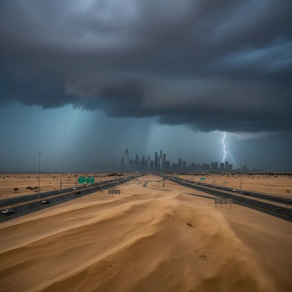
Thursday's pattern reflects what meteorologists call a transitional spring system—atmospheric energy that feeds into convective cloud development, the type of weather phenomenon that generates isolated but intense rain rather than steady precipitation across entire regions. The NCM's forecast model indicates this system will maintain presence throughout daylight hours before gradually weakening after sunset.
The skyline will progress from partly cloudy conditions in early morning toward increasingly dense cloud cover through midday. Within this cloudy envelope, distinct towers of convection—the vertical movement of warm air and moisture—will ignite rain showers. These showers won't distribute uniformly. A neighborhood in Al Barsha might experience 10 minutes of moderate rain while Dubai Marina remains largely unaffected. This highly localized behavior reflects how convective systems operate: they're essentially individual storm cells scattered across the landscape rather than organized weather fronts.
Meteorologically speaking, the Arabian Peninsula's spring season creates favorable conditions for this volatility. Solar heating warms the ground unevenly, and when that warmth rises through moisture-laden air masses moving northward from the Indian Ocean, you get the atmospheric instability that produces these scattered convective events.
The Wind Component: When Gusts Turn Dangerous
Beyond rain, wind will be the day's second major disruption. Baseline wind speeds—from southeasterly to northeasterly flow—will hover between 15 km/h and 30 km/h, manageable conditions for normal operations. Yet during periods when convective clouds develop overhead, downdrafts and outflow from rain shafts will create sudden acceleration in wind speed.
The NCM indicates gusts may spike to 60 km/h, and those moments demand attention from drivers and outdoor workers. At that velocity, wind picks up loose sand and dust particles from the arid surface, transforming clear air into a haze that can reduce visibility to less than 100 meters. Highway authorities have documented numerous traffic incidents during these dust-laced wind events—collisions occur because drivers cannot see vehicles ahead or distinguish lane markings.
The combination of wet pavement (from rain) plus reduced visibility (from dust) creates a compound hazard. Braking distances increase unpredictably. Workers on construction sites and labor-intensive outdoor operations should coordinate with their employers regarding whether work should pause during these gusts. While UAE labor law mandates that employers halt outdoor work during hazardous weather conditions, implementation depends on individual project management and emirate-level enforcement.
Seascape: Rough Patches on Both Coasts
The Arabian Gulf, which laps the western shoreline of Abu Dhabi, Dubai, and Sharjah through Ras Al Khaimah, will experience a transition from baseline slight to moderate sea states into occasional rough conditions. Fishing crews working dawn hours should prepare contingency plans. Port operations in Jebel Ali, Abu Dhabi, and other major cargo terminals may experience minor delays as cranes and loading equipment sometimes pause during rough seas for safety reasons.
Recreational boaters planning excursions should delay trips or at minimum monitor real-time marine bulletins throughout morning hours. The condition swings may sound mild to someone ashore, but they translate into uncomfortable vessel motion and reduced maneuverability for smaller craft.
The Sea of Oman, flanking the eastern emirates' coastline from Fujairah through Khor Fakkan, faces similar dynamics. Commercial fishing operations—a significant livelihood sector for coastal communities—will contend with identical hazards. Unlike the predictable summer monsoon season, spring convective systems offer no advance notice of which hours present the roughest conditions.
What Residents Should Adjust Today
Commuters need to recalibrate travel plans. Morning and evening rush hours overlap with peak rainfall probability. Allow 20-30 minutes of additional buffer time, particularly on heavily-used routes like Sheikh Zayed Road and the E11 highway. Visibility-reducing dust events can cause traffic to slow dramatically without warning—not because of collisions, but because drivers naturally reduce speed when they cannot see clearly.
Parents managing school pickup and drop-off should account for wet conditions. Sidewalks near schools become slip hazards, and parking areas may experience temporary pooling of water.
Construction workers and landscapers—individuals whose work occurs outdoors regardless of conditions—should coordinate with site supervisors. The NCM forecast doesn't specify intensity levels by location, so workers in exposed emirates like Ras Al Khaimah or Fujairah may face stricter work stoppages than their counterparts in Abu Dhabi or Dubai. Employers must make these calls based on real-time observation, not just the morning forecast.
Motorists navigating underpasses should exercise extreme caution. Low-lying passages accumulate water rapidly during convective rainfall. The flood events that occasionally make news aren't caused by sustained heavy rain—they result from 30 minutes of intense precipitation funneling through poor drainage. Never drive through standing water whose depth you cannot verify. Roughly 150 mm of water can float most vehicles, and just 0.6 meters can sweep away cars. The NCM doesn't predict flash flooding explicitly, but spring precipitation events carry that risk.
Why Spring Brings This Weather Pattern
March sits at the cusp of the UAE's climate calendar—the final weeks of cooler-season atmospheric patterns before the permanent high-pressure dome of summer establishes itself. During this window, moisture-bearing air masses from the Indian Ocean occasionally venture northward and interact with solar heating across the Arabian Peninsula. When that collision occurs, convective instability follows.
The country's infrastructure reflects decades of arid assumptions. Drainage systems were engineered for typical years when rainfall measures just 100-150 mm annually across most emirates. Rapid urbanization has added impervious surfaces—concrete, asphalt—that prevent water infiltration and accelerate runoff into those undersized drainage networks. Neighborhoods built before 2010 particularly struggle during intense rainfall events.
Civil defense teams position resources during significant weather events. They monitor flood-prone areas and respond quickly to stranded vehicles in underpasses. Residents with mobility concerns or elderly relatives should ensure they have transportation arranged well before conditions deteriorate.
Tracking the System as Hours Progress
The NCM's mobile application and official social media accounts provide location-based alerts as the system evolves throughout the day. Convective systems change character quickly—a town experiencing light drizzle at 11 AM might face moderate rain by 12:30 PM as a new cell develops overhead, then clear conditions by 1 PM as that cell moves eastward.
Rather than trusting a single morning forecast check, residents should review updated bulletins at mid-morning and mid-afternoon. Employers managing outdoor operations should do the same, adjusting work assignments based on real-time conditions rather than predictions made hours earlier.
Tonight's clearing trend will likely emerge as convective energy dissipates after sunset. Tomorrow's forecast depends on whether this system accelerates eastward or stalls, but current model consensus suggests improving conditions by Friday morning. For now, Thursday requires attentiveness and flexibility from everyone navigating the Emirates.